
Cape Girardeau Previous Residents by Era
The starting source depends on the time period. Recorded land documents trace ownership and legal descriptions. Printed and microfilmed directories can place a household or business at an address in a named edition. Census schedules and newspapers add dates and family context, while maps establish what the street and building looked like in that period. The records below should be read together, because no single source is a complete answer to who lived here before.
| Source | Years It Covers | Where Held | What It Shows |
|---|---|---|---|
| Recorder deed index | 1805–1989 published historic index | County Recorder and linked historic route | Grantor and grantee names, book/page clues, and transfer trail |
| Deed books | 1805–1964 historic route; 1984–present fully indexed deeds | Recorder remote routes and office | Recorded instruments, legal descriptions, and prior references |
| Book/Page band | 1965–1983 deeds | Recorder route and office research | Earlier deed access when name indexing is limited |
| Cape city directories | 1912–13, 1928, 1930, 1932, 1937, 1939, 1949, 1951, 1978, and 1987 in documented SLCL holdings | St. Louis County Library microfilm or print with assistance | Dated address, name, and directory context for a particular edition |
| Federal census | Public schedules released under the federal 72-year rule | National Archives routes and library databases | Household context that can be paired with a directory year |
| Sanborn and plat maps | Sanborn years 1884, 1893, 1900, 1908, 1915, 1920, and 1931 | Library of Congress, County Archive, and local collections | Street, lot, building, and neighborhood context |
Begin with the most recent reliable parcel and deed information if the question is about ownership. Begin with the closest directory year if the question is about a past household. A map often belongs between those steps, especially when the address wording in an older source does not match a modern map label.
Trace Cape Girardeau Previous Deeds
The Cape Girardeau County Recorder of Deeds is the ownership backbone for previous residents research. Start with a current parcel record and move back through transfers, rather than searching an old surname alone. The Recorder identifies 1805 as the start of its land-record context and notes a first recording on June 14 of that year. Documents can reach into the 1790s, but online coverage differs sharply by era.
- Use the County Assessor’s CAMAvision search or GIS map to preserve the current owner spelling, parcel number, situs address, and legal description.
- Find the deed in which that owner appears as grantee. Record the grantor, recording date, book/page, consideration if the instrument shows it, legal description, and any prior-reference clause.
- Search the grantor as a grantee to find the earlier acquisition. Follow the legal description and book/page, not just the street wording, because the description may be the stable connection.
- Repeat the grantee-to-grantor pass one transfer at a time. Treat trusts, estates, entities, and multiple owners as the recorded instrument presents them.
- When the trail reaches a limited online band, take the exact book/page to the Recorder’s office, its equipment, or its staff-assisted access route. Staff can help operate equipment but do not perform title research.
- Grantor
- The party conveying an interest in a recorded instrument. In a sale deed, this is commonly the seller named in that document.
- Grantee
- The party receiving the recorded interest. A grantee is not automatically the person living at the property.
- Chain of title
- The ordered set of recorded transfers used to trace ownership of the same legal description backward.
- Legal description
- Lot, block, subdivision, plat-book/page, or metes-and-bounds language that identifies land in deeds and plats more steadily than a street address.
The Recorder is at #1 Barton Square, Suite 203, Jackson, open Monday through Friday from 8:00 a.m. to 4:30 p.m. Phone 573-243-8123 and recorder@capecounty.us provide additional access channels. Use the office search, remote links, phone, or email when an index does not answer the question, and preserve the record reference in every note.
Cape Girardeau Previous Residents Cutoffs
Recorder coverage explains why a backward trail can slow down. The published historic index to deed books spans 1805 through 1989, while historical deed record books are listed from 1805 through 1964. Deeds from 1984 forward are fully indexed. The 1965 through 1983 deed band is described as Book/Page-only, which means a precise reference or office help may be needed. Deeds of trust have a similar split: fully indexed from 1984 forward and Book/Page-only from 1970 through 1983.
Plats begin in 1806 through the Fidlar route, and surveys are listed from 1991 forward. A plat can connect a lot and block to an older street form. A survey can add later boundary detail. Neither identifies a complete household. Keep the difference clear when using previous residents sources: a recorded owner, an address in a directory, and a map label are separate kinds of evidence.
External ArcaSearch and Fidlar controls were not captured during research. The live field set for grantor, grantee, document type, date range, book/page, legal description, images, downloads, fees, and login state should be checked directly. The County’s recorded coverage list is the reliable guide to where the online search may stop.
Bridge Cape Girardeau Old Addresses
An old street name or number is not enough by itself. Cape Girardeau County assigns new 911 addresses outside incorporated Cape Girardeau and Jackson, while in-city questions go to city planning. A mailing address that says Cape Girardeau may still be outside municipal limits. For a property that crosses a city or county record boundary, test the parcel location, Annexation By Year context, and the legal description before deciding which custodian should have the historical file.
No official complete street-renumbering or street-renaming chronology was found. That is a research gap, not a reason to normalize every older address to a modern street label. Compare the old spelling with a directory street index, a plat, a Sanborn sheet, city council material, and a deed reference. Keep both forms in the research record, then state exactly which source uses which form.
Note: A legal description and plat-book/page reference often bridge old and current address forms better than a street-name search alone.
Pair Cape Girardeau Directory Years
Directories provide the household layer for previous residents research, but only for the edition printed. The St. Louis County Library’s Missouri directory list identifies Cape Girardeau years on microfilm and later print holdings. The documented microfilm years are 1912–13, 1928, 1930, 1932, 1937, 1939, 1949, and 1951. The list also identifies 1978 and 1987 in print with desk assistance. These holdings are a route to ask for a volume, not proof that every edition is online.
The library’s Cape directory year list helps select the next historical edition to request.
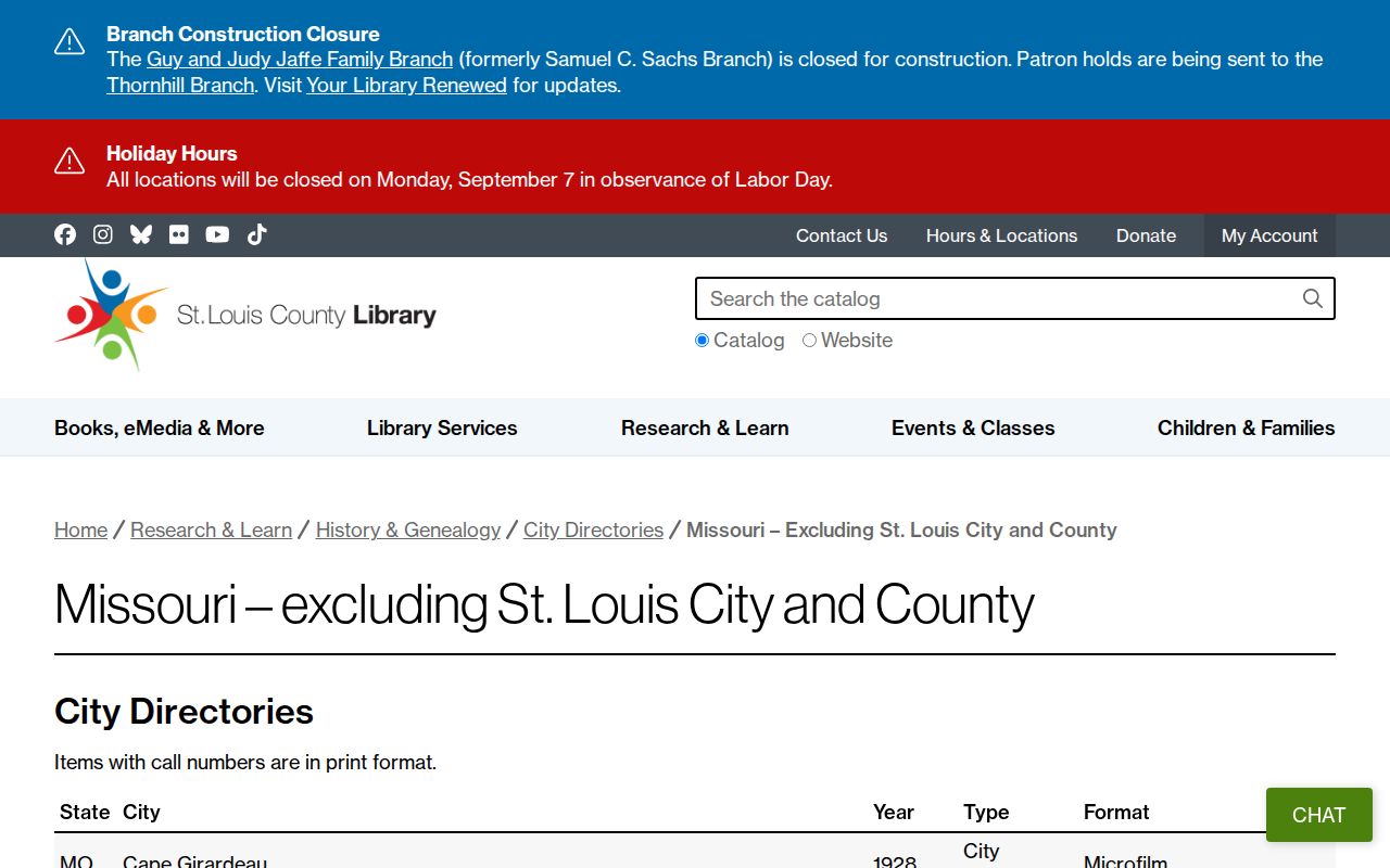
Use the years shown as a request checklist. No open official Cape directory scan or sample entry was inspected, so a researcher should confirm the volume, format, page, and repository before citing an address.
- Choose a directory edition near the deed transfer or the address period being tested.
- Copy the address as printed, including street form, unit, and any notation. Save the edition, publisher, page, and repository.
- Pair that dated entry with the closest public federal census schedule. Compare household names, age patterns, relationships, and address context without assuming that a near match is the same person.
- Check the next available directory edition to see whether the address, household, or business notation changed.
- Resolve conflicts with the original image, the deed chain, map context, and a dated newspaper or obituary notice.
The 1890 federal population schedule was largely destroyed by fire. For that gap, use the surviving Cape sources that are actually available: deed books, tax or county records, maps, newspapers, city directories, and local manuscripts. Do not invent a substitute census entry.
Map Cape Girardeau Previous Addresses
Maps anchor a historical address to a real block. The Library of Congress August 1915 Sanborn collection contains 23 sheets. Official historic material also identifies Cape Girardeau Sanborn years 1884, 1893, 1900, 1908, 1915, 1920, and 1931. The County Archive notes Spanish land-grant maps, a 1901 plat map, a 1910 city-subdivision map, and Sanborn resources. These sources can show streets, lot context, building footprints, materials, and use.
A Sanborn label does not name every resident. Use it between the legal description and the directory entry: first identify the lot or block in the deed, then locate the map sheet, then compare the street and structure context with the dated directory. If a building footprint changes, record the map date and observation instead of assuming an occupancy change.
Cape Girardeau’s map trail is unusually useful because its city story spans Spanish land-grant context, an 1806 plat, later incorporation changes, and annexation maps. The County Recorder’s 1805 start and the layered map dates make a careful address timeline more dependable than a single modern parcel card.
Cape Girardeau Previous Residents Archives
Local repositories hold the material that a recorder index cannot. The Cape Girardeau Public Library, 711 N Clark Street, has the Kirby Genealogy Room with family and regional history, city directories, yearbooks, newspapers, microfilm resources, and Ancestry Library Edition for in-library use. Call 573-334-5279 to confirm a particular year, format, and current access before a visit.
SEMO Kent Library Special Collections & Archives, at 929 Normal Avenue on the third floor, holds city directories, yearbooks, photographs, family papers, and Little River Drainage District material. It is a FamilySearch affiliate, offers newspapers.com access, and can use SHSMO microfilm loan channels. The Glenn House Collection adds Cape directories, historic homes and sites, churches, schools, streets, maps, cemetery files, clippings, and correspondence. Collection restrictions apply to fragile material.
The Cape County Historical Society Research Annex at 110 S High Street maintains history books, family binders, photos, maps, correspondence, clippings, manuscripts, and military material. Its listed research hours are Tuesday through Friday, 10:00 a.m. to 4:00 p.m., with some evening or weekend appointments. The County Archive Center in Jackson holds government and local-association collections. The Cape County Genealogical Society’s research trail directs researchers to city directories, newspapers, church/parish material, yearbooks, FamilySearch, and the County History Center.
Cape Girardeau Previous Residents Endpoints
A household trail often closes with a dated historical source rather than a new address. The Cape Girardeau Democrat is digitized for 1876 through 1909, and the State Historical Society’s county list identifies Missouri Cash-Book holdings through 1935. Search a name with an address, street, church, or legal-notice term, then check the image because optical character recognition can misread names and street numbers.
For a death-era endpoint, the Missouri State Archives database covers death certificates from 1910 through 1975, while the pre-1910 database identifies Cape Girardeau County coverage from 1883 through 1893. An obituary, cemetery record, or probate file may add a date or relationship clue, but it does not permit publication of a surviving person’s current address. Probate is a Circuit Clerk and Case.net handoff, not a Recorder name index; archived files and any copy route should be confirmed with the Clerk.
The City’s known-burials listing for Historic Old Lorimier, New Lorimier, and Fairmount can be inspected at the Cemetery Office or City Hall. A burial place can close a historical timeline for a deceased person. It is not proof of a current household connection or next of kin.
Cape Girardeau Previous Residents Limits
Previous residents research is strongest for house history, family history, estate questions, and local history. It needs a source date and a cautious conclusion. A grantee is not always an occupant. A tax contact is not always an owner. A directory entry is not a census. A map indicates a property feature, not a full household. Cape Girardeau’s distributed evidence is a reason to corroborate a result, not a reason to fill a gap with an unsupported identity claim.
For a record not online, use the custodian that keeps it. The Recorder has remote, office, phone, and email routes; the Library and archives provide repository, microfilm, and staff channels; and a signed County or City records request can identify a defined historical file. Preserve the exact date, custodian, identifier, and what the record does not prove.